UPDATE: July 13, 2019, 3:17 p.m. EDT: The National Hurricane Center advised that after making landfall in Louisiana, Barry weakened to a tropical storm. This doesn't change projections for pummeling rain and the likelihood of extreme flooding.
The lopsided storm Barry is now a hurricane.
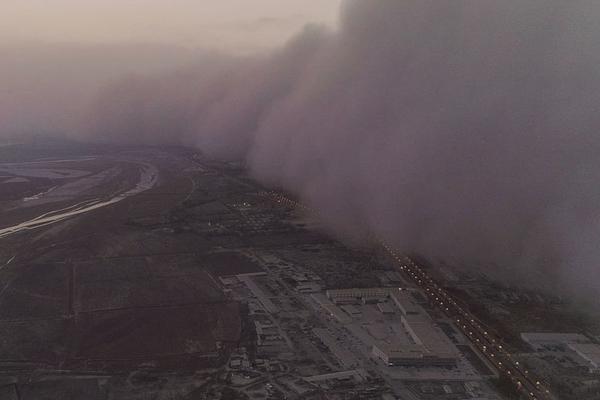
The National Weather Service expects Hurricane Barry, packing 75 mph winds, to pummel portions of Louisiana, Mississippi, other nearby regions with extreme rain and flooding on Saturday and Sunday. Barry might not be a major hurricane, but it has capitalized on exceptionally warm ocean waters to load itself with moisture -- which will soon douse the region.
"It's going to rain hard," Jeff Weber, a meteorologist with the University Corporation for Atmospheric Research (UCAR), told Mashable as Barry picked up steam over the Gulf of Mexico.
"Rainfall is one of the most impactful effects of a tropical storm," National Center for Atmospheric Research (NCAR) hurricane scientist Rosimar Rios-Berrios emphasized Friday evening, as Barry crept toward Louisiana.
"The rainfall does not depend on how strong the storm is," she added. Indeed, Hurricane Harvey -- the largest rain event in U.S. history -- did its most destruction when it was no longer a hurricane.
"...the upgrade to a hurricane means little in terms of the overall impacts from Barry," the National Hurricane Center noted Saturday morning.
Tweet may have been deleted
Portions of Louisiana and Mississippi are forecast to receive between 10 and 20 inches of rain. Some models show 18.5 inches in flood-prone Baton Rouge, Louisiana. "A foot of rain in that area can create quite a problem," noted UCAR's Weber.
Though rainfall would be imminent regardless, as of Friday afternoon it was still unclear if Barry would develop into a storm with hurricane force winds. The lopsided, unorganized storm system was getting hit by winds, known as wind shear, that made organizing into a more potent storm difficult, noted Rios-Berrios.
But Barry overcame those challenges, and as a hurricane will bring surges of ocean water into coastal areas, threaten to overtop levees in the region, and almost certainly bring damaging or catastrophic flooding to certain areas over the next two days.
Tweet may have been deleted
Tweet may have been deleted
In much improved news for New Orleans, however, the National Weather Service projects that -- even with Barry's wind-powered storm surge -- the already-swollen Mississippi will reach 17 feet above sea level -- as opposed to 20 feet expected a few days ago. Many of the city's levees protect the vibrant, historic city from up to 20 feet of flooding along the mighty river -- so New Orleans may avoid a worst-case scenario this weekend.
Still, coastal flooding and the overtopping of other levees has already begun, and the brunt of rain has yet to come.
(责任编辑:焦點)
 WhatsApp announces plans to share user data with Facebook
 Trump trying to sword dance in Saudi Arabia is the most awkward thing you'll see all day
 Valve is trying to stop fake games on Steam by targeting trading cards, of all things
 Facebook rolls out friend features for live video, but no group chats17 questions you can answer if you're a good communicator
Make money or go to Stanford? Katie Ledecky is left with an unfair choice.
This is Katie Ledecky's world right now, and the rest of us are just living in it. Want proof? Ledec
...[详细]Facebook and Google dominate in online news — but for very different topics
 On the internet, there's Google and Facebook, and then there's everyone else. Digital publishers kno
...[详细]
On the internet, there's Google and Facebook, and then there's everyone else. Digital publishers kno
...[详细] Twitter co-founder Evan Williams wants you to know he's super sorry for any role the social media pl
...[详细]
Twitter co-founder Evan Williams wants you to know he's super sorry for any role the social media pl
...[详细]'Game of Thrones' keeps rolling out Season 7 teasers and zero new footage
 If you're in the business of writing and reading the internet, you may have noticed a lot of Game of
...[详细]
If you're in the business of writing and reading the internet, you may have noticed a lot of Game of
...[详细]Watch MTV's Video Music Awards 2016 livestream
It's MTV Video Music Awards night. Are you ready?Kanye's going to be there, and he's going to say th
...[详细]Secret Facebook documents reveal how site battles violent content
 Facebook's closely guarded, secret guidelines for monitoring violence, hate speech, and revenge porn
...[详细]
Facebook's closely guarded, secret guidelines for monitoring violence, hate speech, and revenge porn
...[详细]'Nancy' isn't a person, it's a podcast. Oh, and it's super, super gay.
 When I ask the creators of new LGBTQ podcast Nancyhow gay their show is, they're caught a little off
...[详细]
When I ask the creators of new LGBTQ podcast Nancyhow gay their show is, they're caught a little off
...[详细]Trump trying to sword dance in Saudi Arabia is the most awkward thing you'll see all day
President Donald Trump bobbed and swayed during a traditional sword dance in Saudi Arabia, outside o
...[详细]Slack goes down again, prompting anxiety everywhere
 Panic briefly took over on Tuesday when everyone's favorite messaging app/millstone went down tempor
...[详细]
Panic briefly took over on Tuesday when everyone's favorite messaging app/millstone went down tempor
...[详细]People are really happy that smoking has been banned in the Philippines
 Philippine President Rodrigo Duterte, better known for his offensive statements and crackdown on dru
...[详细]
Philippine President Rodrigo Duterte, better known for his offensive statements and crackdown on dru
...[详细]Katy Perry talks 'Rise,' her next batch of songs, and how to survive Twitter
Surprise! Fans are as obsessed with the 'Twin Peaks' revival as the original